- Anexos
- Glosario
- Iconos y cursores en gvSIG
- Relación de errores conocidos de gvSIG 1.1
- Repliegue de ventanas del lanzador de instalación y las ventanas de la aplicación (Sólo Linux y tipo de escritorio KDE)
- Error en la gestión de campos tipo Date en gvSIG
- Error al intentar unir dos tablas con el nombre del campo con acento
- Error al configurar un navegador web en preferencias (sólo para Linux)
- No se pueden etiquetar los campos de una tabla dbf que se han unido a un dxf
- Rotar un elemento insertado en un mapa
- No funciona correctamente la herramienta de simetría sobre una capa de anotaciones.
- No se puede cambiar el formato de una capa WMS una vez cargada.
- Problemas para reconocer la impresora (sólo para Linux y Java 1.5)
- Fallo en los resultados de las funciones de agrupamiento en el geoproceso disolver.
- Errores conocido de la herramienta 'Exportar a ráster'
Anexos
Glosario
ADL Gazetter Protocol: Standard defining how the communication between ADL gazetteer clients and servers must be.
ADL GCS (ADL Gazetteer Content Standard): Although it is not an official standard it is the de facto set of rules used to defined the relationship between a toponym and its coordinates. It can supply other attributes such as the region where the toponym is settled, or the nature of this datum.
ANZLIC (Australian and New Zealand Land Information Council): Is the organization in charge of the development of the SDI in these two countries.
Band: Frequency interval from the electromagnetic spectrum. For example, the first band of the TM sensor is defined in the range of 0.45-.052 mm.
Database: Set of data structured in order to enable the storage, consultation and upgrading in a computer system. The relational database is a concrete case in which the information is organized in relations (often known as “tables”). Relations are a set of tuples (“records”) and a tuple integrates information about an element in a set of fields (one field for each attribute of the element); if two tables share a field containing values within the same domain then it is possible to apply a union operation. The union links the tuples according on the values in the linking field.
BMP: Acronym for Bit Map Picture; is a basic image format. It is simple and pretty normalized; it is a excellent format for sharing data and fast when analyzing and processing images. However, since it is not compressed it does not improve the transmission and disk accessing times. BMP is often used win RGB 24 bits.
CAD: Acronym for Computer Assistant Design. It is an automatic system oriented to design, draw and graphical visualization.
Cartography: Set of operations and processes that take part in the creation, edition and analysis of maps.
catalogue, Service of: Allows the publication and searching of information (metadata) describing data (cartography), services, applications and any other kind of resources. The catalogue services are necessary to supply search and invocation capabilities over registered resources within an SDI. A Open Geospatial Consortium spec establishes how a Catalogue Service must be standard and interoperable.
CatMDEdit: Is a computer application for creating and editing geographic metadata based upon the “OSI19115. Geographic Information – Metadata” norm. Among its features, it is an open-source project, multiplatform (Windows / UNIX) and multilingual (Spanish and English) as well.
CEN (European Committee of Standarization): Official organization for normalization of the European Union. Replaces country specific techniques by common rules for the whole Union in collaboration with international organizations and its members in Europe (CENELEC for electronics and ETSI for telecommunications).
CEN TC 287 (Technical Committee of Geographic Information): Set of standards for manipulating geographical information (approximately 20).
Clearinghouse: A distributed service for metadata about geospatial data locating. Allows to search in one or several nodes or servers that have been registered in the Clearinghouse of the Internet. It is the term used by FGDC, equivalent to the OGC’s Catalogue Service.
CNIDR z39.50 Server (clearinghouse for Networked Information Discovery and Retrieval): z39.50 server, also known as zDist.
Compression: Technique for reducing the amount of bits needed for storing or transmitting information. There are lossless or destructive compressions (for instance, GIF and JPG for the digital images respectively).
Coordinate: Value defining the position in a reference system. The coordinates can be lineal (Cartesian) or polar (spherical), depending on the reference system.
Cota en ingles es Height que se autodefine CSDGM (Content Standard for Digital Geospatial Metadata: Determines the metadata that exists in a geographical position and how to access to them. It does explain neither how to organize the data in a computer nor which software to use.
Datum: Geometric reference system used to numerically express the geodesic position of a point over the terrain. Each datum is defined according of an ellipsoid and a point where the ellipsoid and the Earth are tangent. In Spain for example, the datum uses the Hayford (or International 1924) ellipsoid and the tangency point is Postdam (Germany).
DublinCore: Set of metadata elements created to make the electronic resource discovery easier. ebRIM (ebXML Registry Information Model): Specifies a set of services that make the communication between companies easier using ebXML.
ebRS (ebXML Registry: Services and Protocols): Defines the services that the ebXML Registry and other related protocols offer.
ebXML (electronic Business XML): Is a Standard that defines an XML-document format for sharing information between companies.
Element of a metadata: Discrete metadata unit. Entity of a metadat**: Set of elements describing the same aspect of the data.
Ellipsoid: Simplified description of the Earth shape: the ellipsoids are defined by equatorial and polar radiuses.
EPSG: European Petroleum Survey Group.
Scale: Constant relation between a distance in a map and the corresponding real distance.
FGDC (Federal Geographic Data Committee): Organization in charge of developing the National Spatial Data Infrastructure (NSDI) of the United States of America.
Geodesy: The science that studies the shape of the Earch in the gravitational field.
Geoid: Is the level surface, equipotential in the gravitational field, which adopts an irregular three-dimensional spheroid. Due to the dependency on the mass distribution inside the Earth, it is impossible to represent it mathematically. The mathematical shape used to do it is the ellipsoid that approximately fits better the Earth shape. The geoid is coincident with the mean ocean surface when they are quiet, virtually extended for the continents land.
Georreference: The art of assigning geographic coordinates to an object or structure. This concept applied to a digital image involves a set of geometric operations that allow assigning to each image pixel a pair of coordinates (x, y) in a projection system.
GIF: Graphic Interchange Format. Developed by CompuServe to provide a standard and platform-independent format. The GIF format is limited to a maximum of 256 colours. It is a reasonable limitation since most of the PC screens support 256 colours at most. In general, GIF is recommended for simple images. When the background has textures they are not useful because the computer tries to find the closest colour, and some distortions may appear in this process and the result is an inaccurate displaying for the image.
GPS: Acronym for global positioning system. It refers to the system by means of which it is possible to approximately calculate a position in the Earth using a signal received from several satellites (called the GPS constellation) simultaneously.
Grid: Is a net composed by two or more series of arcs in which the member of each series intersects with the members of the other series in an algorithmic way.
gvSIG: A Geographical Information handling tool. Features a user-friendly interface, an agile access to the most common vector and raster formats. It can integrate local and remote (the Internet) data through connections following some protocols specified by the Open Geospatial Consortium.
Spindle: Part of a sphere limited by two meridians or maximum circles. In the UTM projection each spindle is defined by two meridians separated by a distance of 6 degrees (for a total circle round of 360 degrees) and by two parallels of 80 degrees latitude North and South.
SDI: An SDI (Spatial Data Infrastructure) is a computer system integrated by a set of resources (catalogues, servers, programs, data, applications, web pages, and so on), for manage Geographic Information (maps, satellite images, toponymes, etc.), available from the Internet, that follow a set of interoperational capacity conditions (rules, specifications, protocols, interfaces, etc) that allow an user to use them using a simple browser and combine then for his/her needs.
IDEE: Acronym for Infraestructura de Datos Espaciales de España, or Spanish Spatial Data Infrastructure. The goal of the IDEE is to integrate through Internet the geographic data, metadata, services and information produced in Spain. So, any potential can identify, select, and access to these resources from the IDEE’s site where any node and other site of other geographic information producers of local, regional or even national wide areas available in Spain.
Digital Image: Graphical representation of an object which is, in fact, a regular matrix that is a collection of a reflectance values. The reflectance values are usually measured by sensors of a specific range of light wavelengths; examples of these sensors are those aerial-transported such are aircrafts or satellites or those integrated in a scanner used to digitalize printed documents.
Nomenclator Service: Offers the possibility of locating a geographic place by its name. It is defined as a service that receives an input that is the name of the place (toponym), with the common possibilities: exact match, starting with, contains, etc. and returns the location, by means of the coordinates, of the place. Additionally, the query by name also handles other criteria such as the spatial extension where to look up, or the type of the place (river, mountain, towns …). If one or more occurrences are found, the service supplies a list of the places found with any additional attribute describing it for the user can choose the desired one. There is an Open Geospatial Consortium spec describing how a Nomenclator Service must be to be standard and interoperable.
Iconos y cursores en gvSIG
Iconos que aparecen en el ToC
The following table shows the icons which appear in the ToC to the left of the name and which vary depending on the type of layer.
| Nombre original | Icono | Descripción |
|---|---|---|
| icon-layer | A generic icon for a layer which does not have its own icon. | |
| icon-layer-group | An icon for a group of layers in the ToC. | |
| icon-layer-vect.shp | An icon used by default for a vector layer. | |
| icon-layer-wms | An icon used for WMS layers in the OGC service. | |
| icon-layer-wfs | An icon used for WFS layers in the OGC service. | |
| icon-layer-raster | An icon used for raster layers. |
Cursores
These cursors are used by the application depending on the tool which is enabled at that time.
| Name original | Icon | Description |
|---|---|---|
| cursor-query-information |  |
A cursor used when the information request tool is selected. |
| cursor-zoom-in |  |
A cursor which appears when zooming in. |
| cursor-zoom-out |  |
A cursor which appears when zooming out. |
| cursor-hiperlink |  |
A cursor used for the hyperlink tool. |
| cursor-insert-poligon |  |
A cursor used by the insert polygon tool in an editing session. |
| cursor-insert-rectangle |  |
A cursor used by the insert rectangle tool in an editing session. |
| cursor-pan |  |
A cursor which appears when panning is allowed. |
| cursor-query-area |  |
A cursor used by the area measuring tool. |
| cursor-query-distance |  |
A cursor used by the distance measuring tool. |
| cursor-select-by-rectangle |  |
A cursor which appears when selecting by rectangle. |
| cursor-select-point |  |
A cursor used to make a point selection. |
Acciones
Icons which appear in the tool bar or in the application menus.
| Name original | Name in gvSIG | Icon | Description |
|---|---|---|---|
| application-console | Information console |  |
This displays the application’s error console. |
| application-exit | Exit |  |
This closes the application. |
| application-preferences | Preferences |  |
This displays the application’s preferences dialogue box. |
| edit-copy | Copy |  |
This copies documents |
| edit-cut | Cut |  |
This cuts documents. |
| edit-delete | Delete |  |
This deletes documents. |
| edit-paste | Copy |  |
This pastes documents. |
| edit-redo | Redo |  |
This redoes an action. |
| edit-undo | Undo |  |
This undoes another action |
| document-print |  |
This allows access to the print configuration dialogue box. | |
| project-new | Create a new Project |  |
This creates a new blank project. |
| project-open | Open existing project |  |
This shows the “Open” dialogue box which allows an existing project to be located. |
| project-save-as | Save as |  |
This saves the changes made to a project. |
| project-save | Save project | |
This saves the changes made to a project. |
| layer-add | Add layer |  |
This shows the dialogue box to add layers to a view. |
| layer-show-attribute-table | See table |  |
This shows the table of attributes of the selected layer. |
| edition-command-stack | Command stack |  |
This shows the command stack window of an editing session. |
| edition-complex-selection | Complex selection |  |
This activates the complex selection tools on a view. |
| edition-geometry-copy | Copy |  |
This makes a copy of the selected element. |
| edition-geometry-edit-vertex | Edit vertex |  |
This allows a geometry vertex to be edited. |
| edition-geometry-insert-line | Line |  |
This allows a line to be inserted in a line layer editing session. |
| edition-geometry-move | Move |  |
This moves the selected geometries. |
| edition-geometry-rotate | Rotate |  |
This allows the selected geometries to be rotated. |
| edition-geometry-scale | Escale |  |
This scales (reduces or increases) the selected geometries. |
| edition-geometry-select | Select |  |
This selects a geometry |
| edition-geometry-symmetry | Symmetry |  |
This divides a geometry symmetrically. |
| edition-insert-geometry-arc | Arc |  |
This activates the tool to insert an arc in the layer. |
| edition-insert-geometry-circle | Circle |  |
This activates the tool to insert a circle in the layer. |
| edition-insert-geometry-ellipse | Ellipse |  |
This activates the tool to insert an ellipse in the layer. |
| edition-insert-geometry-multipoint | Multipoint |  |
This activates the tool to insert points in a multipoint geometry. |
| edition-insert-geometry-point | Point |  |
This activates the point insertion tool. |
| edition-insert-geometry-poligon | Polygon |  |
This activates the polygon insertion tool. |
| edition-insert-geometry-polyline | Poliline |  |
This activates the tool to insert a polyline. |
| edition-insert-geometry-rectangle | Rectangle |  |
This activates the rectangle insertion tool. |
| edition-modify-geometry-internalpolygon | Internal polygon |  |
This allows a polygon to be extracted from a closed geometry. |
Mapas
| Name original | Name in gvSIG | Icon | Description |
|---|---|---|---|
| layout-add-border | Graphic line |  |
This adds a border to the map. |
| layout-bring-to-front | Bring to front |  |
This puts the selected element in front of other elements. |
| layout-clear-selection | Clear selection |  |
This eliminates the selected element. |
| layout-command-stack | Command stack |  |
This displays the map’s command stack window. |
| layout-edit-vertex | Edit vertex |  |
This allows vertexes of graphic elements inserted in the map to be edited. |
| layout-export-pdf | Export PDF |  |
This exports the map to pdf format. - |
| layout-export-ps | Export a PS |  |
This exports the map to postscript format. |
| layout-group | Group graphics |  |
This groups together the selected elements of the map. |
| layout-insert-box | Insert box |  |
This inserts a box in the map. |
| layout-insert-circle | Circle |  |
This inserts a circle in the map |
| layout-insert-image | Insert image |  |
This inserts an image in the map. |
| layout-insert-legend | Insert legend |  |
This adds the view legend to the map. |
| layout-insert-line | Insert line |  |
This tool allows a line to be added to the map. |
| layout-insert-north | Insert north |  |
Adds the element “North” to the map. |
| layout-insert-point | Insert point |  |
This tool allows a point to be inserted in the map. |
| layout-insert-poligon | Insert polygon |  |
This tool allows a polygon to be inserted in the map. |
| layout-insert-polyline | Insert poliline |  |
This tool allows a polyline to be inserted in the map. |
| layout-insert-scalebar | Insert escale |  |
This tool allows the view scalebar to be inserted in the map. |
| layout-insert-text | Insert Text |  |
This inserts a text in the map. |
| layout-insert-view | Insert View |  |
This inserts a view in the map. |
| layout-page-setup | Page setup |  |
This opens the map’s page preference dialogue box. |
| layout-pan | Frame the view ç |  |
This activates the panning tool to move around the view. |
| layout-save-template | Save as template |  |
This saves the map design as a template. |
| layout-select | Select by rectangle |  |
This selects an element in the map. |
| layout-send-to-back | Send to back |  |
This sends the selected element to the back. |
| layout-set-size-position | Size/position |  |
This changes the size and position of an element in the map. |
| layout-show-tag | Move image to be georeferenced |  |
This allows you to move the image to be georeferenced in the view. |
| layout-template-open | Open template |  |
This loads a previously saved map template. |
| layout-ungroup | Ungroup graphics |  |
This ungroups a set of graphics inserted in the map. |
| layout-zoom-center-in | Zoom in to centre |  |
This zooms into the centre of the map. |
| layout-zoom-center-out | Zoom out from centre |  |
This zooms out from the centre of the map. |
| layout-zoom-fit | Zoom fit |  |
This adjusts the map zoom to the size of the window. |
| layout-zoom-in | Zoom in |  |
This zooms into the selected area of the map. |
| layout-zoom-out | Zoom out |  |
This zooms out from the selected area of the map. |
| layout-zoom-real | Zoom 1:1 |  |
This enlarges the map to the size of the screen. |
| layout-zoom-selected | Zoom to selection |  |
This zooms to the selected elements. |
Tablas
| Name original | Name in gvSIG | Icon | Description | |
|---|---|---|---|---|
| table-filter | Filter |  |
This opens the filter dialogue box in a table. | |
| table-join | Join |  |
This opens the dialogue box to join tables. | |
| table-link | Link |  |
This opens the dialogue box to link tables. | |
| table-order-asc | Ascending order |  |
This puts the records in a selected field of the table in ascending order. | |
| table-order-desc | Descending order |  |
This puts the records in a selected field of the table in descending order. | |
| table-selection-up | Move the selection up |  |
This moves the selected records to the top of the table. | |
| table-statistics | Statistics |  |
This opens the statistics dialogue box in the table. | |
Vistas
| Original Name | Name in gvSIG | Icon | Description |
|---|---|---|---|
| view-add-event-layer | Add event layer |  |
This opens the dialogue box for adding an event layer to the view |
| view-center-to-point | Centre the view on a point |  |
his opens a dialogue box in which you can input the required cordinates you wish the view to centre on. |
| view-clear-selection | Clear selection |  |
This deselects the elements selected in the view. |
| view-locator | Locate by attribute |  |
This opens the dialogue box to select by attributes |
| view-pan | Panning |  |
This activates the panning tool. |
| view-query-area | Measure area |  |
This activates the area measuring tool |
| view-query-distance | Measure distances |  |
This activates the distance measuring tool |
| view-query-link | Hyperlink |  |
This activates the hyperlink query tool |
| view-save-to-raster | Save to raster |  |
This allows you to select the area of the view you wish to save to the raster layer |
| view-select-by-polygon | Select by polygon |  |
This activates the tool for selecting geometries of a layer which are located in a polygon |
| view-select-by-rectangle | Select by rectangle |  |
This activates the tool for selecting geometries of a layer which are located in a rectangle |
| view-select-geometry | Select by point |  |
This activates the tool for selecting geometries of a layer |
| view-query-information | Information |  |
This activates the tool for providing information about a point |
| view-zoom-back | Previous zoom |  |
This shows the view with the previous zoom. |
| view-zoom-center-in | Zoom in from centre |  |
This zooms in from the centre of the view |
| view-zoom-center-out | Zoom out from centrer |  |
This zooms out from the centre of the view |
| view-zoom-in | Zoom in |  |
This zooms into the selected area |
| view-zoom-manager | Zoom manager |  |
This opens the zoom manager dialogue box. |
| view-zoom-map-contents | Zoom fit |  |
This zooms to shows all load layers. |
| view-zoom-out | Zoom out |  |
This zooms out from the area of the selected view. |
| view-zoom-to-seleccion | Zoom to selection |  |
This zooms in to the selected elements of a layer. |
| gazetteer-search | Gazetteer |  |
This opens the gazetteer search tool (search by place names) |
| catalog-clear-point | Delete gazetter point |  |
This deletes the reference point added by the catalogue or gazetteer search. |
| catalog-search | Catalogue search |  |
This opens the catalogue search tool. |
| scripting-console | Jython console |  |
This opens the scripting languages console.. |
Relación de errores conocidos de gvSIG 1.1
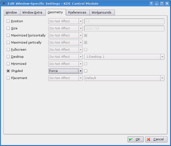
Repliegue de ventanas del lanzador de instalación y las ventanas de la aplicación (Sólo Linux y tipo de escritorio KDE)
An error has been detected which affects the way in which the application windows and the gvSIG installer are displayed. There are occasions on which the windows roll up and only the title bar can be seen. To solve this problem, follow the steps below:
Open the application and place the cursor over the gvSIG icon in the top left-hand corner. Right click on the mouse.
If the window has already rolled itself up, open the window again before continuing.To do this, right click on the mouse on the window’s title bar and disable the “Shade” option so that the window is displayed again.
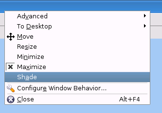
Select the “Configure window behaviour” option from the contextual menu.
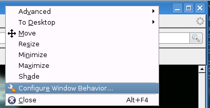
In the following window, select the “Specific window preferences” option and click on “New”.
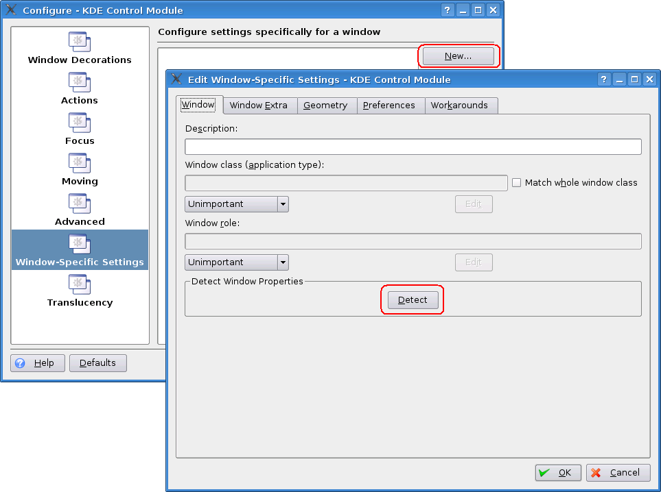
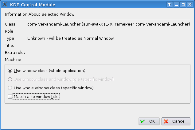
In the next window, click on the “Detect” button and click on any part of the gvSIG view.
A new window will then open. Select the option “Use window type (all the application” and click on “Ok”.
Return to the “Edit specific window options” window, go to the “Geometry” tab, select the “Shade” option and click on the “Force” option in the pull-down menu.
Error en la gestión de campos tipo Date en gvSIG
At present there is no uniform date format in gvSIG, which leads to problems involving date value management.
Problems have been detected when performing calculations with Date values using the Field Calculator.
Error al intentar unir dos tablas con el nombre del campo con acento
At present, it is not possible to correctly join two tables whose field names contain accents.
Error al configurar un navegador web en preferencias (sólo para Linux)
In the web browser option of the gvSIG preferences menu, the section “Execute own command” does not work correctly in this version.
No se pueden etiquetar los campos de una tabla dbf que se han unido a un dxf
At present, it is not possible to see the labels on the field of a dbf table which has been joined to a dxf table by means of the table-joining process.
Rotar un elemento insertado en un mapa
At present, graphics cannot be rotated clockwise as there is no arrow with which to do so. If you wish to rotate graphics in this direction, input the corresponding degrees (together with a minus sign) in the associated text box.
No funciona correctamente la herramienta de simetría sobre una capa de anotaciones.
At present, it is not possible to use the symmetry tools on an annotation layer.
No se puede cambiar el formato de una capa WMS una vez cargada.
A problem has been detected with some WMS servers in which, on attempting to access the layer properties again and change the image formats, these are not displayed correctly.
Problemas para reconocer la impresora (sólo para Linux y Java 1.5)
If gvSIG displays a warning message indicating that there is no default printer even if there is a printer installed, go to the system preferences menu and set the printer as default.
Fallo en los resultados de las funciones de agrupamiento en el geoproceso disolver.
It has been found that the results obtained after applying the grouping functions in the “Dissolve” geoprocess are not correct.
Errores conocido de la herramienta 'Exportar a ráster'
When attempting to clip jpg2000 and ecw layers, the RGB bands are interchanged in the resulting layer
